The 'water cycle' is an issue closely related to climate geoengineering technologies. OE
Article from USGS science for a changing world - Summanry of the Water Cycle
http://water.usgs.gov/edu/watercyclesummary.html
Summary of the Water Cycle
What is the water cycle?
 What is the water cycle? I can easily answer that—it is "me" all over! The water cycle describes the existence and movement of water on, in, and above the Earth. Earth's water is always in movement and is always changing states, from liquid to vapor to ice and back again. The water cycle has been working for billions of years and all life on Earth depends on it continuing to work; the Earth would be a pretty stale place without it.
Where does all the Earth's water come from? Primordial Earth was an incandescent globe made of magma, but all magmas contain water. Water set free by magma began to cool down the Earth's atmosphere, and eventually the environment became cool enough so water could stay on the surface as a liquid. Volcanic activity kept and still keeps introducing water into the atmosphere, thus increasing the surface- and groundwater volume of the Earth.
A quick summary of the water cycle
Here is a quick summary of the water cycle. The links in this paragraph go to the detailed Web pages in our Web site for each topic. A shorter summary of each topic can be found further down in this page, though.

The water cycle has no starting point, but we'll begin in the oceans, since that is where most of Earth's water exists. The sun, which drives the water cycle, heats water in the oceans. Some of it evaporates as vapor into the air; a relatively smaller amount of moisture is added as ice and snow sublimate directly from the solid state into vapor. Rising air currents take the vapor up into the atmosphere, along with water from evapotranspiration, which is water transpired from plants and evaporated from the soil. The vapor rises into the air where cooler temperatures cause it to condense into clouds.
Air currents move clouds around the globe, and cloud particles collide, grow, and fall out of the sky as precipitation. Some precipitation falls as snow and can accumulate as ice caps and glaciers, which can store frozen water for thousands of years. Snowpacks in warmer climates often thaw and melt when spring arrives, and the melted water flows overland as snowmelt. Most precipitation falls back into the oceans or onto land, where, due to gravity, the precipitation flows over the ground as surface runoff. A portion of runoff enters rivers in valleys in the landscape, with streamflow moving water towards the oceans. Runoff, and groundwater seepage, accumulate and are stored as freshwater in lakes.
Not all runoff flows into rivers, though. Much of it soaks into the ground as infiltration. Some of the water infiltrates into the ground and replenishes aquifers (saturated subsurface rock), which store huge amounts of freshwater for long periods of time. Some infiltration stays close to the land surface and can seep back into surface-water bodies (and the ocean) as groundwater discharge, and some groundwater finds openings in the land surface and emerges as freshwater springs. Yet more groundwater is absorbed by plant roots to end up as evapotranspiration from the leaves. Over time, though, all of this water keeps moving, some to reenter the ocean, where the water cycle "ends" ... oops - I mean, where it "begins."
Main components of the water cycle
Global water distribution
Water storage in oceans: Saline water existing in oceans and inland seas
The ocean as a storehouse of water
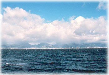 The water
 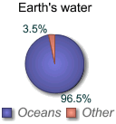 cycle sounds like it is describing how water moves above, on, and through the Earth ... and it does. But, in fact, much more water is "in storage" for long periods of time than is actually moving through the cycle. The storehouses for the vast majority of all water on Earth are the oceans. It is estimated that of the 332,600,000 cubic miles (mi3) (1,386,000,000 cubic kilometers (km3)) of the world's water supply, about 321,000,000 mi3 (1,338,000,000 km3) is stored in oceans. That is about 96.5 percent. It is also estimated that the oceans supply about 90 percent of the evaporated water that goes into the water cycle.
During colder climatic periods more ice caps and glaciers form, and enough of the global water supply accumulates as ice to lessen the amounts in other parts of the water cycle. The reverse is true during warm periods. During the last ice age glaciers covered almost one-third of Earth's land mass, with the result being that the oceans were about 400 feet (122 meters) lower than today. During the last global "warm spell," about 125,000 years ago, the seas were about 18 feet (5.5. meters) higher than they are now. About three million years ago the oceans could have been up to 165 feet (50 meters) higher.
Oceans in movement
Evaporation: The process by which water is changed from liquid to a gas or vapor
Evaporation and why it occurs
 Evaporation is the process by which water changes from a liquid to a gas or vapor. Evaporation is the primary pathway that water moves from the liquid state back into the water cycle as atmospheric water vapor. Studies have shown that the oceans, seas, lakes, and rivers provide nearly 90 percent of the moisture in our atmosphere via evaporation, with the remaining 10 percent being contributed by plant transpiration.
Heat (energy) is necessary for evaporation to occur. Energy is used to break the bonds that hold water molecules together, which is why water easily evaporates at the boiling point (212° F, 100° C) but evaporates much more slowly at the freezing point. Net evaporation occurs when the rate of evaporation exceeds the rate of condensation. A state of saturation exists when these two process rates are equal, at which point, the relative humidity of the air is 100 percent. Condensation, the opposite of evaporation, occurs when saturated air is cooled below the dew point (the temperature to which air must be cooled at a constant pressure for it to become fully saturated with water), such as on the outside of a glass of ice water. In fact, the process of evaporation removes heat from the environment, which is why water evaporating from your skin cools you.
Evaporation drives the water cycle
Sublimation: The changing of snow or ice to water vapor without melting
.") Sublimation describes the process of snow and ice changing into water vapor without first melting into water. Sublimation is a common way for snow to disappear in certain climates.
Sublimation describes the process of snow and ice changing into water vapor without first melting into water. Sublimation is a common way for snow to disappear in certain climates.It is not easy to actually see sublimation happen, at least not with ice. One way to see the results of sublimation is to hang a wet shirt outside on a below-freezing day. Eventually the ice in the shirt will disappear. Actually, the best way to visualize sublimation is to not use water at all, but to use carbon dioxide instead, as this picture shows."Dry ice" is solid, frozen carbon dioxide, which sublimates, or turns to gas, at the temperature -78.5 °C (-109.3°F). The fog you see in the picture is a mixture of cold carbon dioxide gas and cold, humid air, created as the dry ice sublimates.
Sublimation occurs more readily when certain weather conditions are present, such as low relative humidity and dry winds. It also occurs more at higher altitudes, where the air pressure is less than at lower altitudes. Energy, such as strong sunlight, is also needed. If I was to pick one place on Earth where sublimation happens a lot, I might choose the south side of Mt. Everest. Low temperatures, strong winds, intense sunlight, very low air pressure - just what is needed for sublimation to occur.
Evapotranspiration: The process by which water vapor is discharged to the atmosphere as a result of evaporation from the soil and transpiration by plants.
 Although some definitions of evapotranspiration include evaporation from surface-water bodies, such as lakes and even the ocean, on this Web site, evapotranspiration is defined as the water lost to the atmosphere from the ground surface and the transpiration of groundwater by plants through their leaves.
Transpiration: The release of water from plant leaves
 Transpiration is the process by which moisture is carried through plants from roots to small pores on the underside of leaves, where it changes to vapor and is released to the atmosphere. Transpiration is essentially evaporation of water from plant leaves. It is estimated that about 10 percent of the moisture found in the atmosphere is released by plants through transpiration.
Plant transpiration is an invisible process—since the water is evaporating from the leaf surfaces, you don't just go out and see the leaves "breathing". During a growing season, a leaf will transpire many times more water than its own weight. A large oak tree can transpire 40,000 gallons (151,000 liters) per year.
Atmospheric factors affecting transpiration
- Temperature:Transpiration rates go up as the temperature goes up, especially during the growing season, when the air is warmer.
- Relative humidity: As the relative humidity of the air surrounding the plant rises the transpiration rate falls. It is easier for water to evaporate into dryer air than into more saturated air.
- Wind and air movement: Increased movement of the air around a plant will result in a higher transpiration rate.
- Soil-moisture availability: When moisture is lacking, plants can begin to senesce (premature ageing, which can result in leaf loss) and transpire less water.
- Type of plant: Plants transpire water at different rates. Some plants which grow in arid regions, such as cacti and succulents, conserve precious water by transpiring less water than other plants.
Water storage in the atmosphere: Water stored in the atmosphere as vapor, such as clouds and humidity
The atmosphere is full of water
 The water cycle is all about storing water and moving water on, in, and above the Earth. Although the atmosphere may not be a great storehouse of water, it is the superhighway used to move water around the globe. There is always water in the atmosphere. Clouds are, of course, the most visible manifestation of atmospheric water, but even clear air contains water—water in particles that are too small to be seen. One estimate of the volume of water in the atmosphere at any one time is about 3,100 cubic miles (mi3) or 12,900 cubic kilometers (km3). That may sound like a lot, but it is only about 0.001 percent of the total Earth's water volume. If all of the water in the atmosphere rained down at once, it would only cover the ground to a depth of 2.5 centimeters, about 1 inch.
Condensation: The process by which water is changed from vapor to liquid
Condensation is the process in which water vapor in the air is changed into liquid water. Condensation is crucial to the water cycle because it is responsible for the formation of clouds. These clouds may produce precipitation, which is the primary route for water to return to the Earth's surface within the water cycle. Condensation is the opposite of evaporation.
You don't have to look at something as far away as a cloud to notice condensation, though. Condensation is responsible for ground-level fog, for your glasses fogging up when you go from a cold room to the outdoors on a hot, humid day, for the water that drips off the outside of your glass of iced tea, and for the water on the inside of your home windows on a cold day.Condensation in the air
 Even though clouds are absent in a crystal clear blue sky, water is still present in the form of water vapor and droplets which are too small to be seen. Depending on meteorological conditions, water molecules will combine with tiny particles of dust, salt, and smoke in the air to form cloud droplets, which grow and develop into clouds, a form of water we can see. Cloud droplets can vary greatly in size, from 10 microns (millionths of a meter) to 1 millimeter (mm), and even as large as 5 mm. This process occurs higher in the sky where the air is cooler and more condensation occurs relative to evaporation. As water droplets combine (also known as coalescence) with each other, and grow in size, clouds not only develop, but precipitation may also occur. Precipitation is essentially water cloud in its liquid or solid form falling form the base of a cloud. This seems to happen too often during picnics or when large groups of people gather at swimming pools.
You might ask ... why is it colder higher up?
Precipitation: The discharge of water, in liquid or solid state, out of the atmosphere, generally upon a land or water surface
 Precipitation is water released from clouds in the form of rain, freezing rain, sleet, snow, or hail. It is the primary connection in the water cycle that provides for the delivery of atmospheric water to the Earth. Most precipitation falls as rain.
How do raindrops form?
 The clouds floating overhead contain water vapor and cloud droplets, which are small drops of condensed water. These droplets are way too small to fall as precipitation, but they are large enough to form visible clouds. Water is continually evaporating and condensing in the sky. If you look closely at a cloud you can see some parts disappearing (evaporating) while other parts are growing (condensation). Most of the condensed water in clouds does not fall as precipitation because their fall speed is not large enough to overcome updrafts which support the clouds. For precipitation to happen, first tiny water droplets must condense on even tinier dust, salt, or smoke particles, which act as a nucleus. Water droplets may grow as a result of additional condensation of water vapor when the particles collide. If enough collisions occur to produce a droplet with a fall velocity which exceeds the cloud updraft speed, then it will fall out of the cloud as precipitation. This is not a trivial task since millions of cloud droplets are required to produce a single raindrop.
Precipitation rates vary geographically and over time
The map below shows average annual precipitation, in millimeters and inches, for the world. The light green areas can be considered "deserts". You might expect the Sahara area in Africa to be a desert, but did you think that much of Greenland and Antarctica are deserts?

On average, the 48 continental United States receives enough precipitation in one year to cover the land to a depth of 30 inches (0.76 meters).
Water storage in ice and snow: Freshwater stored in frozen form, generally in glaciers, icefields, and snowfields
ice caps around the world
 Although the water cycle sounds like it is describing the movement of water, in fact, much more water is in storage at any one time than is actually moving through the cycle. By storage, we mean water that is locked up in its present state for a relatively long period of time, such as in ice caps and glaciers.
The vast majority, almost 90 percent, of Earth's ice mass is in Antarctica, while the Greenland ice cap contains 10 percent of the total global ice-mass. The Greenland ice cap is an interesting part of the water cycle. The ice cap became so large over time (about 600,000 cubic miles (mi3) or 2.5 million cubic kilometers (km3)) because more snow fell than melted. Over the millenia, as the snow got deeper, it compressed and became ice. The ice cap averages about 5,000 feet (1,500 meters) in thickness, but can be as thick as 14,000 feet (4,300 meters). The ice is so heavy that the land below it has been pressed down into the shape of a bowl. In many places, glaciers on Greenland reach to the sea, and one estimate is that as much as 125 mi3 (517 km3) of ice "calves" into the ocean each year—one of Greenland's contributions to the global water cycle. Ocean-bound icebergs travel with the currents, melting along the way. Some icebergs have been seen, in much smaller form, as far south as the island of Bermuda.
Ice and glaciers come and go

Some glacier and ice cap facts
- Glacial ice covers 10 - 11 percent of all land.
- According to the National Snow and Ice Data Center (NSIDC), if all glaciers melted today the seas would rise about 230 feet (70 meters).
- During the last ice age (when glaciers covered more land area than today) the sea level was about 400 feet (122 meters) lower than it is today. At that time, glaciers covered almost one-third of the land.
- During the last warm spell, 125,000 years ago, the seas were about 18 feet (5.5 meters) higher than they are today. About three million years ago the seas could have been up to 165 feet (50.3 meters) higher.
Snowmelt runoff to streams: The movement of water as surface runoff from snow and ice to surface water
 If you live in Florida or on the French Riviera you might not wake up everyday wondering how melting snow contributes to the water cycle. But, in the world-wide scheme of the water cycle, runoff from snowmelt is a major component of the global movement of water. In the colder climates much of the springtime runoff and streamflow in rivers is attributable to melting snow and ice. The effect of snowmelt on potential flooding, mainly during the spring, is something that causes concern for many people around the world. Besides flooding, rapid snowmelt can trigger landslides and debris flows.
Contribution of snowmelt to streamflow
 for four years for the North Fork American River at North Fork Dam in California.")
Note that runoff from snowmelt varies not only by season but also by year. Compare the high peaks of streamflows for the year 2000 with the much smaller streamflows for 2001. It looks like a major drought hit that area of California in 2001. The lack of water stored as snowpack in the winter can affect the availability of water (for streamflow) in streams the rest of the year. This can have an effect on the amount of water in reservoirs located downstream, which in turn can affect water available for irrigation and the water supply for cities and towns.
Surface runoff: Precipitation runoff which travels over the soil surface to the nearest stream channel
Surface runoff is precipitation runoff over the landscape
 When rain hits saturated or impervious ground it begins to flow overland downhill. It is easy to see if it flows down your driveway to the curb and into a storm sewer, but it is harder to notice it flowing overland in a natural setting. During a heavy rain you might notice small rivulets of water flowing downhill. Water will flow along channels as it moves into larger creeks, streams, and rivers. This picture gives a graphic example of how surface runoff (here flowing off a road) enters a small creek. The runoff in this case is flowing over bare soil and is depositing sediment into the river (not good for water quality). The runoff entering this creek is beginning its journey back to the ocean.
As with all aspects of the water cycle, the interaction between precipitation and surface runoff varies according to time and geography. Similar storms occurring in the Amazon jungle and in the desert Southwest of the United States will produce different surface-runoff effects. Surface runoff is affected by both meteorological factors and the physical geology and topography of the land. Only about a third of the precipitation that falls over land runs off into streams and rivers and is returned to the oceans. The other two-thirds is evaporated, transpired, or soaks into groundwater. Surface runoff can also be diverted by humans for their own uses.
Streamflow: The movement of water in a natural channel, such as a river
The U.S. Geological Survey (USGS) uses the term "streamflow" to refer to the amount of water flowing in a river. Although USGS usually uses the term "stream" when discussing flowing water bodies, in these pages we'll use "rivers" more often to describe flowing creeks, streams, and rivers, since that is probably what you are more familiar with.Importance of rivers
 Rivers are invaluable to not only people, but to life everywhere. Not only are rivers a great place for people (and their dogs) to play, but people use river water for drinking-water supplies and irrigation water, to produce electricity, to flush away wastes (hopefully, but not always, treated wastes), to transport merchandise, and to obtain food. Rivers are indeed major aquatic landscapes for all manners of plants and animals. Rivers even help keep the aquifers underground full of water by discharging water downward through their streambeds. And, we've already mentioned that the oceans stay full of water because rivers and runoff continually refreshes them.
Watersheds and rivers
Streamflow is always changing
 Streamflow is always changing, from day to day and even minute to minute. Of course, the main influence on streamflow is precipitation runoff in the watershed. Rainfall causes rivers to rise, and a river can even rise if it only rains very far up in the watershed—remember that water that falls in a watershed will eventually drain by the outflow point. The size of a river is highly dependent on the size of its watershed. Large rivers have watersheds with lots of surface area; small rivers have smaller watersheds. Likewise, different size rivers react differently to storms and rainfall. Large rivers rise and fall slower and at a slower rate than small rivers. In a small watershed, a storm can cause 100 times as much water to flow by each minute as during baseflow periods, but the river will rise and fall possibly in a matter of minutes and hours. Large rivers may take days to rise and fall, and flooding can last for a number of days. After all, it can take days for all the water that fell hundreds of miles upstream to drain past an outflow point.
Freshwater storage: Freshwater existing on the Earth's surface
One part of the water cycle that is obviously essential to all life on Earth is the freshwater existing on the land surface. Just ask your neighbor, a tomato plant, a trout, or that pesky mosquito. Surface water includes the streams (of all sizes, from large rivers to small creeks), ponds, lakes, reservoirs (man-made lakes), and freshwater wetlands. The definition of freshwater is water containing less than 1,000 milligrams per liter of dissolved solids, most often salt.
Surface water keeps life going
 As this satellite picture of the Nile Delta in Egypt shows, life can even bloom in the desert if there is a supply of surface water (or groundwater) available. Water on the land surface really does sustain life, and this is as true today as it was millions of years ago. I'm sure dinosaurs held their meetings at the local watering hole 100 million years ago, just as antelopes in Africa do today. And, since groundwater is supplied by the downward percolation of surface water, even aquifers are happy for water on the Earth's surface. You might think that fish living in the saline oceans aren't affected by freshwater, but, without freshwater to replenish the oceans they would eventually evaporate and become too saline for even the fish to survive.
Usable freshwater is relatively scarce
Infiltration: The downward movement of water from the land surface into soil or porous rock
Groundwater begins as precipitation
 Anywhere in the world, a portion of the water that falls as rain and snow infiltrates into the subsurface soil and rock. How much infiltrates depends greatly on a number of factors. Infiltration of precipitation falling on the ice cap of Greenland might be very small, whereas, as this picture of a stream disappearing into a cave in southern Georgia, USA shows, a stream can act as a direct funnel right into groundwater!
Some water that infiltrates will remain in the shallow soil layer, where it will gradually move vertically and horizontally through the soil and subsurface material. Eventually it might enter a stream by seepage into the stream bank. Some of the water may infiltrate deeper, recharging ground-water aquifers. If the aquifers are shallow or porous enough to allow water to move freely through it, people can drill wells into the aquifer and use the water for their purposes. Water may travel long distances or remain in ground-water storage for long periods before returning to the surface or seeping into other water bodies, such as streams and the oceans.
In places where the water table (the top of the saturated zone) is close to the land surface and where the water can move through the aquifer at a high rate, aquifers can be replenished artificially
Groundwater storage: Water existing for long periods below the Earth's surface
Stored water as part of the water cycle
 Large amounts of water are stored in the ground. The water is still moving, possibly very slowly, and it is a part of the water cycle. Most of the water in the ground comes from precipitation that infiltrates downward from the land surface. The upper layer of the soil is the unsaturated zone, where water is present in varying amounts that change over time, but does not saturate the soil. Below this layer is the saturated zone, where all of the pores, cracks, and spaces between rock particles are saturated with water. The term groundwater is used to describe this area. Another term for groundwater is "aquifer," although this term is usually used to describe water-bearing formations capable of yielding enough water to supply peoples' uses. Aquifers are a huge storehouse of Earth's water and people all over the world depend on groundwater in their daily lives.
To find water, look under the table ... the water table
 I hope you appreciate my spending an hour in the blazing sun to dig this hole at the beach. It is a great way to illustrate the concept of how at a certain depth the ground, if it is permeable enough to hold water, is saturated with water. The top of the pool of water in this hole is the water table. The breaking waves of the ocean are just to the right of this hole, and the water level in the hole is the same as the level of the ocean. Of course, the water level here changes by the minute due to the movement of the tides, and as the tide goes up and down, the water level in the hole moves, too.
In a way, this hole is like a dug well used to access groundwater, albeit saline in this case. But, if this was freshwater, people could grab a bucket an supply themselves with the water they need to live their daily lives. You know that at the beach if you took a bucket and tried to empty this hole, it would refill immediately because the sand is so permeable that water flows easily through it, meaning our "well" is very "high-yielding" (too bad the water is saline). To access freshwater, people have to drill wells deep enough to tap into an aquifer. The well might have to be dozens or thousands of feet deep. But the concept is the same as our well at the beach—access the water in the saturated zone where the voids in the rock are full of water.
Groundwater discharge: The movement of water out of the ground
There's more water than just what you can see
 You see water all around you every day as lakes, rivers, ice, rain and snow. There are also vast amounts of water that are unseen—water existing in the ground. And even though groundwater is unseen, it is moving below your feet right now. As part of the water cycle, groundwater is a major contributor to flow in many streams and rivers and has a strong influence on river and wetland habitats for plants and animals. People have been using groundwater for thousands of years and continue to use it today, largely for drinking water and irrigation. Life on Earth depends on groundwater just as it does on surface water.
Groundwater flows underground
 Some of the precipitation that falls onto the land infiltrates into the ground to become groundwater. Once in the ground, some of this water travels close to the land surface and emerges very quickly as discharge into streambeds, but, because of gravity, much of it continues to sink deeper into the ground. If the water meets the water table (below which the soil is saturated), it can move both vertically and horizontally. Water moving downward can also meet more dense and water-resistant non-porous rock and soil, which causes it to flow in a more horizontal fashion, generally towards streams, the ocean, or deeper into the ground.
As this diagram shows, the direction and speed of ground-water movement is determined by the various characteristics of aquifers and confining layers (which water has a difficult time penetrating) in the ground. Water moving below ground depends on the permeability (how easy or difficult it is for water to move) and on the porosity (the amount of open space in the material) of the subsurface rock. If the rock has characteristics that allow water to move relatively freely through it, then groundwater can move significant distances in a number of days. But groundwater can also sink into deep aquifers where it takes thousands of years to move back into the environment, or even go into deep ground-water storage, where it might stay for much longer periods.
Spring: A place where a concentrated discharge of groundwater flows at the ground surface
What is a spring?
 A spring is a water resource formed when the side of a hill, a valley bottom or other excavation intersects a flowing body of groundwater at or below the local water table. A spring is the result of an aquifer being filled to the point that the water overflows onto the land surface. They range in size from intermittent seeps, which flow only after much rain, to huge pools with a flow of hundreds of millions of liters per day.
Springs may be formed in any sort of rock, but are more prevalent in limestone and dolomite, which fracture easily and can be dissolved by rainfall that becomes weakly acidic. As the rock dissolves and fractures, spaces can form that allow water to flow. If the flow is horizontal, it can reach the land surface, resulting in a spring.
Spring water is not always clear
 Water from springs usually is remarkably clear. Water from some springs, however, may be "tea-colored." This picture shows a natural spring in southwestern Colorado. Its red iron coloring and metals enrichment are caused by groundwater coming in contact with naturally occurring minerals present as a result of ancient volcanic activity in the area. In Florida, many surface waters contain natural tannic acids from organic material in subsurface rocks, and the color from these streams can appear in springs. If surface water enters the aquifer near a spring, the water can move quickly through the aquifer and discharge at the spring vent. The discharge of highly colored water from springs can indicate that water is flowing quickly through large channels within the aquifer without being filtered through the limestone.
Thermal springs
 Thermal springs are ordinary springs except that the water is warm and, in some places, hot, such as in the bubbling mud springs in Yellowstone National Park, Wyoming. Many thermal springs occur in regions of recent volcanic activity and are fed by water heated by contact with hot rocks far below the surface. Even where there has been no recent volcanic action, rocks become warmer with increasing depth. In such areas water may migrate slowly to considerable depth, warming as it descends through rocks deep in the Earth. If it then reaches a large crevice that offers a path of less resistance, it may rise more quickly than it descended. Water that does not have time to cool before it emerges forms a thermal spring. The famous Warm Springs of Georgia and Hot Springs of Arkansas are of this type. And, yes, warm springs can even coexist with icebergs, as these happy Greenlanders can tell you.
Global water distribution
For an estimated explanation of where Earth's water exists, look at the chart below. By now, you know that the water cycle describes the movement of Earth's water, so realize that the chart and table below represent the presence of Earth's water at a single point in time. If you check back in a thousand or million years, no doubt these numbers will be different!
Notice how of the world's total water supply of about 332.5 million cubic miles of water, over 97 percent is saline. And, of the total freshwater, over 68 percent is locked up in ice and glaciers. Another 30 percent of freshwater is in the ground. Fresh surface-water sources, such as rivers and lakes, only constitute about 22,300 cubic miles (93,100 cubic kilometers), which is about 1/150th of one percent of total water. Yet, rivers and lakes are the sources of most of the water people use everyday.
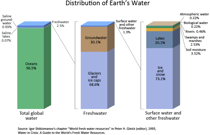
Source: Igor Shiklomanov's chapter "World fresh water resources" in Peter H. Gleick (editor), 1993, Water in Crisis: A Guide to the World's Fresh Water Resources (Oxford University Press, New York).
(To see the complete table below see Summanry of the Water Cycle
| Water source | Water volume, in cubic miles | Water volume, in cubic kilometers | Percent of freshwater | Percent of total water |
|---|---|---|---|---|
| Oceans, Seas, & Bays | 321,000,000 | 1,338,000,000 | -- | 96.5 |
| Ice caps, Glaciers, & Permanent Snow | 5,773,000 | 24,064,000 | 68.7 | 1.74 |
| Groundwater | 5,614,000 | 23,400,000 | -- | 1.7 |
| Fresh | 2,526,000 | 10,530,000 | 30.1 | 0.76 |
| Saline | 3,088,000 | 12,870,000 | -- | 0.93 |
| Soil Moisture | 3,959 | 16,500 | 0.05 | 0.001 |
| Ground Ice & Permafrost | 71,970 | 300,000 | 0.86 | 0.022 |
| Lakes | 42,320 | 176,400 | -- | 0.013 |
| Fresh | 21,830 | 91,000 | 0.26 | 0.007 |
| Saline | 20,490 | 85,400 | -- | 0.006 |
| Atmosphere | 3,095 | 12,900 | 0.04 | 0.001 |
| Swamp Water | 2,752 | 11,470 | 0.03 | 0.0008 |
| Rivers | 509 | 2,120 | 0.006 | 0.0002 |
| Biological Water | 269 | 1,120 | 0.003 | 0.0001 |
| Source: Igor Shiklomanov's chapter "World fresh water resources" in Peter H. Gleick (editor), 1993, Water in Crisis: A Guide to the World's Fresh Water Resources (Oxford University Press, New York). | ||||

No comments:
Post a Comment